The Deep Fork River (DFR) runs 230 meandering river miles, with its headwaters in the middle of Oklahoma City (OKC). Many people use this river recreationally and it is a vital habitat for wildlife in the urbanized OKC area. The DFR supplies all water to Lake Arcadia, located in Edmond, OK. Its neighboring river, The Oklahoma River has been subjected to publicized cleanup efforts and infrastructure redevelopment. Due to lack of attention, the OKC stretch of the DFR has been heavily impacted by garbage, runoff, and erosion from commercial and urban development. In March of 2023, we photo-documented over 6 miles of this stretch of the river to provide insight on its condition, and to hopefully inspire cleanup efforts and improved protective measures in the future.
Oklahoma's Deep Fork River: A Headwaters in Peril

_edited.jpg)
_edited.jpg)
Location of photo documented stretch of the DFR:
Full length of the DFR
Who are we?
We are concerned citizens, and also members of the UCO (University of Central Oklahoma) community. From previous research projects in the OKC area, we recognized that the Deep Fork River (DFR) is an under-appreciated, neglected, and heavily impacted natural resource. We decided to photo-document the urbanized upper stretches of the DFR to help raise awareness of the condition of this important Oklahoma river. We floated the upper stretches of the river in kayaks in March of 2023, taking over 700 pictures of the river and its accumulated litter. You can see many of our pictures in the photo collages below.
Our team was composed of the following individuals:

Dr. Matthew Parks
UCO Professor of Biology
Alexa Kirksey
UCO undergraduate
Dr. Sean Laverty
UCO Professor of Mathematics
The above scalable map shows the length of DFR we photo-documented, divided into sections 1 (dark blue), 2 (light blue), and 3 (yellow).

View of DFR downstream from N. Pennsylvania Avenue (October, 2023)
DFR Section 1 - N. Pennsylvania Ave to N. Hudson Ave
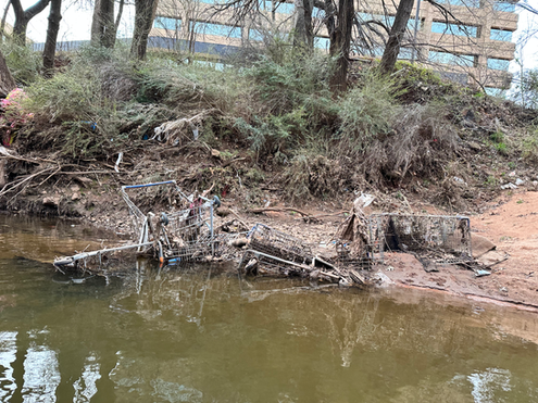
The first section of the DFR is approximately 1.7 river miles. Our documentation began behind The Container Store on N. Pennsylvania Ave, past The Penn Square Mall, and ended by the corner of NW. 54th St. and N. Hudson Ave. The river began shallow and narrow (~57 ft across), then began to open up (~222 ft across) around the mall parking lot, before narrowing again at N. Classen Blvd. From N. Western Ave. to I-44, the river flows through a concrete lined section. Along with large amounts of plastic, there were many shopping carts located inside the river.
The photos below represent current litter accumulation, and are displayed in upstream to downstream fashion on a collage that scrolls from left to right. The photos can be selected to enlarge, and several can be found on the interactive map to the right.

Bend of DFR upstream from N. Lincoln BLVD and I-44 (November, 2023)
DFR Section 2 - N. Hudson Ave to N. Kelley Ave
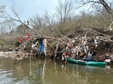
The second section of the DFR is approximately 2.2 miles. Documentation ended just past N. Kelley Ave. Overall, this portion of the river was fairly narrow with several wider pockets reaching widths of approximately 125 feet. The majority of the litter in this section consists of large amounts of fabrics, such as clothing and mattresses. Much of this litter has become entangled in tree branches.
The photos below represent current litter accumulation, and are displayed in upstream to downstream fashion on a collage that scrolls from left to right. The photos can be selected to enlarge, and several can be found on the interactive map to the right.

River meander downstream of N. Martin Luther King Avenue bridge (November, 2023)
DFR Section 3 - N. Kelley Ave to I-35
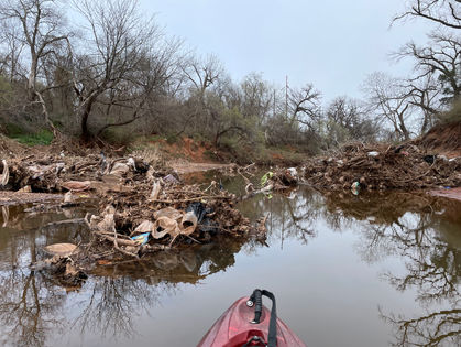
The third section of the DFR is approximately 2.3 miles. Our documentation went behind Remington Park and ended at I-35. The width of the river remained consistent, around approximately 80 feet. This section of the river contained a large amount of tires, shopping carts, and plastics.
The photos below represent current litter accumulation, and are displayed in upstream to downstream fashion on a collage that scrolls from left to right. The photos can be selected to enlarge, and several can be found on the interactive map to the right.


